As the last field season of the winter atlas approaches, it’s time to take stock and prioritize, as we did early in the last breeding season. To recap, winter field work is split into an early period that runs from 1 November until the end of December, and a late period that runs from 1 January until the end of February. Continue reading “Early winter priorities”
Atlas while you Christmas Count
Christmas Bird Count season is upon us. The first Connecticut count is on Tuesday, making today the start of Count Week for those of us in the Storrs area. (For a complete list of counts, click here.) All data collected during a Christmas Count can also be used for the winter atlas, of course, although doing this requires a little planning.
The easiest way to ensure that data can be used for the atlas is to enter observations directly into eBird, with a separate checklist for each site that you visit. Then, as with regular atlas work, simply share the checklist with “ctbirdatlas” and the data will come straight to us. If you are not an eBird user, then you can use the data forms on the atlas web site.
The one tricky part is that it is crucial to ensure that all birds on a given checklist fall within a single atlas block, as Christmas Count territories do not always align neatly with atlas block boundaries. For example, the area I survey on the Storrs count is a roughly diamond-shaped area between routes 195, 44, 32, and 175. As you can see from the image below, this area lies almost entirely within block 40D.
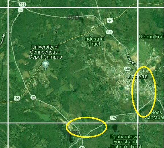
But, the two corners circled in yellow, fall in the adjacent blocks to the east and south. Consequently, when I’m in these parts of the territory, I have to remember to keep separate lists for birds seen on either side of the boundary.
The reason this matters is that all observations are assigned to blocks based on the point location for the checklist (the “pin” that you see on an eBird map). If that pin is in one block and you wander into the adjacent block, then we have no way of knowing which birds were seen in which block. Even if you add comments to the checklist, there is no way for us to subdivide the records into separate blocks except by re-entering all of the data into new checklists.
A good way to keep track of exactly where you are, relative to block boundaries, is to download the Google Earth app to your phone. On the atlas web site, we also have a .kml file showing the block boundaries, that you can save to your phone and then view in Google Earth. We’ve written about this before, but the key steps are:
-
- Download the Google Earth app.
- Save the block boundary map to your phone. Instructions on how to download the map can be found on the atlas web site here, and the map itself is here. Beware that these instructions were written for an iPhone in 2018 and some details might have changed, or might differ slightly on other devices.
- Add the block boundary map to Google Earth. On my current phone, this is a little different from 2018, but I found that these instructions worked well when I tried this afternoon.
As a bonus, we also have a file that you can download to show the Christmas Bird Count circles. If you save this and pull it up in Google Earth, you will get an image that looks like this one (note that we are missing a couple of recently added count circles):
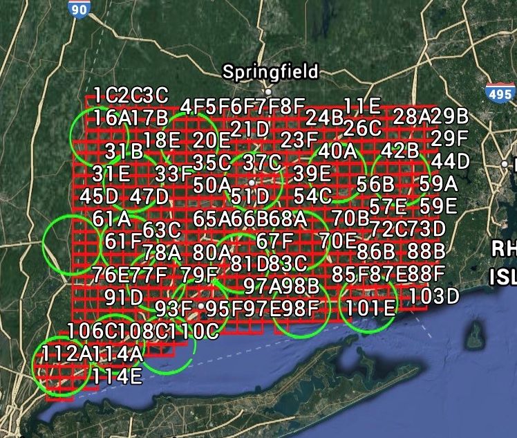
With this in hand, you can zoom in to wherever you are, look for the blue dot to see your location, and make sure that you know which side of a block boundary you are on. By viewing both the block map and count circle map together, you can also make sure you stay within the circle.
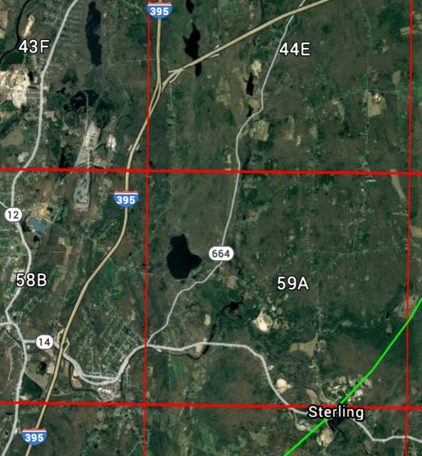
To give another example, this next map shows my territory for the Moosup area of the Trailwoods Christmas Count. Most of my area in is blocks 44E and 59A, but it also includes the portion of 58B that lies east of 395. The green arc in the bottom left corner, shows the edge of the count circle, so keeping the app open lets me check to make sure I know exactly which block I’m in, and whether I’m staying with the Christmas Count circle.
One last thing. If you have used Google Earth in the past, but have found that the block grid sometimes disappears (this can happen, for example, after upgrading the app), we have instructions for how to “pin” the grid in place so that it is always visible when you open the app (thanks to Chris Howe for providing these, and to others for testing them).
Report those owls!
A hooting great horned owl in my yard last night, prompts me to remind everyone that, although we are still in the depths of the winter atlas, we are also a month into the reporting safe dates for Connecticut’s largest nesting owl. Any great horneds heard or seen between now and June should be considered potential breeders. If they are in breeding habitat, then they will count for both the breeding and winter atlases. Continue reading “Report those owls!”
Planning your winter atlas surveys
Field work for the winter atlas is well under way. The goal is to spend approximately 10 hours surveying each block during November-December and then another 10 hours during January-February. If you’ve not yet begun, consider using the Thanksgiving break to make a plan and start your surveys. Continue reading “Planning your winter atlas surveys”
Block boundary problems – part 2
Yesterday, I wrote about the problem of birds moving across block boundaries, and how that can complicate the assignment of breeding codes. A related problem involves accurately identifying the block that a given observation falls in, and arises when a birding site lies on the boundary between blocks. Continue reading “Block boundary problems – part 2”
Summer Bird Counts and the atlas project
Connecticut birding has a long history of citizen science, of which the Connecticut Bird Atlas is only the most recent incarnation. Summer Bird Counts (SBCs) – the mid-year equivalent of Christmas Bird Counts – have been run in the state for nearly three decades and aim to count birds within several 15-mile diameter circles scattered across the state to help track population changes. Continue reading “Summer Bird Counts and the atlas project”
2,174 and counting …
As of this afternoon, 2,174 eBird checklists have been shared with the ctbirdatlas account. Within those checklists, we have received almost 10,000 individual records with breeding codes attached, representing 152 potential breeding species. Given that the breeding season is still getting going for many species, this level of effort bodes well for the project’s success and we are very grateful to everyone who has shared their checklists. Continue reading “2,174 and counting …”
Why only 20 hours? Can I do more?
For the breeding portion of the atlas we are asking block adopters to commit to 20 hours of time spent looking for breeding birds in their block over the course of the three-year study. To some, this does not seem like very much time and many have asked whether 20 hours is enough time to adequately survey a block, and whether then can spend more time.
The short answer is that you can spend as much time as you like in your block – we will take (and use) as much data as you send us. Continue reading “Why only 20 hours? Can I do more?”
Backing up records from “unsafe” dates
A week or so ago, I provided two rules of thumb to reduce confusion over the use of safe dates:
1. If you are unsure whether to submit a record, do so.
2. Always submit any record that confirms breeding (i.e., warrants a 2-letter code).
The second rule has a firm basis in the way we will use the atlas data – anything that is confirmed is a solid record no matter what. The first rule, however, simply defers the decision of what to include to us during the data management phase of the project. This is good in that it means we can standardize what gets included and what does not, but we still have to decide when a record is counted as breeding evidence. Continue reading “Backing up records from “unsafe” dates”
Making safe dates simpler
Over the past week or two, we have received a number of questions about when people should start recording species for the atlas. Continue reading “Making safe dates simpler”